PREVIOUS
✖
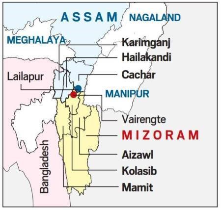
Assam-Mizoram border dispute
July 30 , 2021
1369 days
807
0
- Mizoram was carved out of Assam as a Union Territory in 1972.
- By 1987, it became a full-fledged state.
- The two states have sparred over this 164.6 km long inter-state border over the past, sometimes leading to violent clashes.
- The dispute stems from two notifications passed under British era.
- First, notification of 1875 that differentiated Lushai Hills from the plains of Cachar.
- Second, notification of 1933 that demarcates a boundary between Lushai Hills and Manipur.
- Mizoram claims that the land is theirs is based on an 1875 notification, which came from the Bengal Eastern Frontier Regulation Act of 1873.
- Assam for its part, claims that the land is theirs.
- It goes by a 1933 notification by the state government that demarcated the Lushai Hills, which Mizoram was formerly known as, from the province of Manipur.
- During colonial times, Mizoram was known as Lushai Hills, a district of Assam.

Leave a Reply
Your Comment is awaiting moderation.