PREVIOUS
✖
India State of Forest Report
February 14 , 2018
2549 days
2794
0
- The Forest Survey of India (FSI) which is under the Ministry of Environment has released a report called India State of Forest Report, a biennial report.
- As per this report, India posted a marginal 0.21% rise in the area under forest between 2015 and 2017.
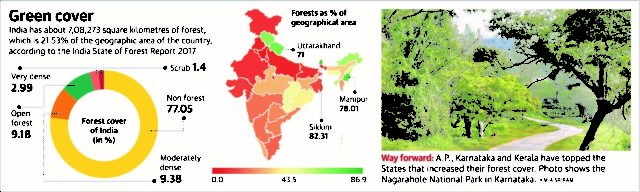
- The document says that India has about 7, 08,273 square km of forest, which is 21.53% of the geographic area of the country. Total geographical area of India is 32,87,569 sq. km
- The top five States where maximum forest cover has increased are Andhra Pradesh, Karnataka, Kerala, Odisha and Telangana.
- India’s northeast showed a decrease in the forest cover. The five States where forest cover has decreased most are Mizoram, Nagaland, Arunachal Pradesh, Tripura and Meghalaya.
- The main reasons for the decrease are shifting cultivation, other biotic pressures, rotational felling, diversion of forest lands for developmental activities, submergence of forest cover, agriculture expansion and natural disasters
- Madhya Pradesh has the largest forest cover in the country in terms of area, followed by Arunachal Pradesh and Chhattisgarh.
- In terms of percentage of forest cover with respect to the total geographical area, Lakshadweep’s the highest forest cover, followed by Mizoram and Andaman and Nicobar Island.
- India is ranked 10th in the world, with 24.4% of land area under forest and tree cover.
- The forest survey for the first time mapped 633 districts through satellite-mapping.

Leave a Reply
Your Comment is awaiting moderation.